Stories Etched in Concrete and Steel

Today we delve into decoding curb stamps and pavement inscriptions as municipal time capsules, revealing how contractor imprints, WPA-era dates, survey benchmarks, and even spray-painted utility codes quietly document the growth of neighborhoods, repairs after disasters, and civic priorities. Learn how to interpret these overlooked marks to trace history, verify timelines, and see your block with new, informed curiosity.

Reading the Language Underfoot

Like marginalia in a citywide ledger, inscriptions embedded in curbs, sidewalks, and cast iron speak a condensed, practical language. By noticing letterforms, spacing, material changes, and contextual clues—near corners, hydrants, or driveways—you can reconstruct construction phases, name forgotten firms, and connect individual blocks to broader infrastructure campaigns that reshaped entire districts.

Color Code Essentials

The APWA color code, used across North America, assigns red to electric power, yellow to gas and petroleum, orange to communications, blue to potable water, green to sewers, purple to reclaimed water, pink to temporary survey, and white to proposed excavation—an essential legend for decoding street hieroglyphs.

Temporary Survey and Excavation Notices

Strings of letters, stake flags, and survey whiskers often mark centerlines, bore paths, planned cuts, and restoration limits. Even small details—like a circled T for test pit or double line for trench—can forecast timelines, noise levels, lane closures, and when fresh asphalt or patches will appear.

Mapping Memory: From Curbs to Archives

Deciphering inscriptions grows more powerful when paired with maps, photos, and public records. Building your own lightweight atlas transforms scattered observations into a coherent narrative, connecting a stamped corner to permit timelines, capital budgets, and oral histories that anchor personal curiosity in trustworthy evidence.

Create a Neighborhood Inventory

Start with a simple spreadsheet and a phone camera. Record location coordinates, date observed, legible text, materials, and nearby context like hydrants or poles. Over time, patterns emerge, revealing construction waves, favored contractors, and subtle shifts in municipal standards, like joint spacing or seal placement.

Photographing Legibly and Responsibly

Photograph inscriptions at oblique angles to catch raking light, avoid harsh glare, and emphasize shallow relief. Include a scale like a coin or ruler, confirm street names, and back up originals to cloud storage, preserving not just images but provenance that future neighbors or researchers can trust.

Design, Accessibility, and Change Over Time

Streets are living systems that adapt to accessibility, safety, and climate. Reading the built surface reveals policy changes: when curb ramps appeared, why tactile warnings spread, which intersections were widened, and how paving technologies evolved, layering new materials atop older stories without erasing every trace.

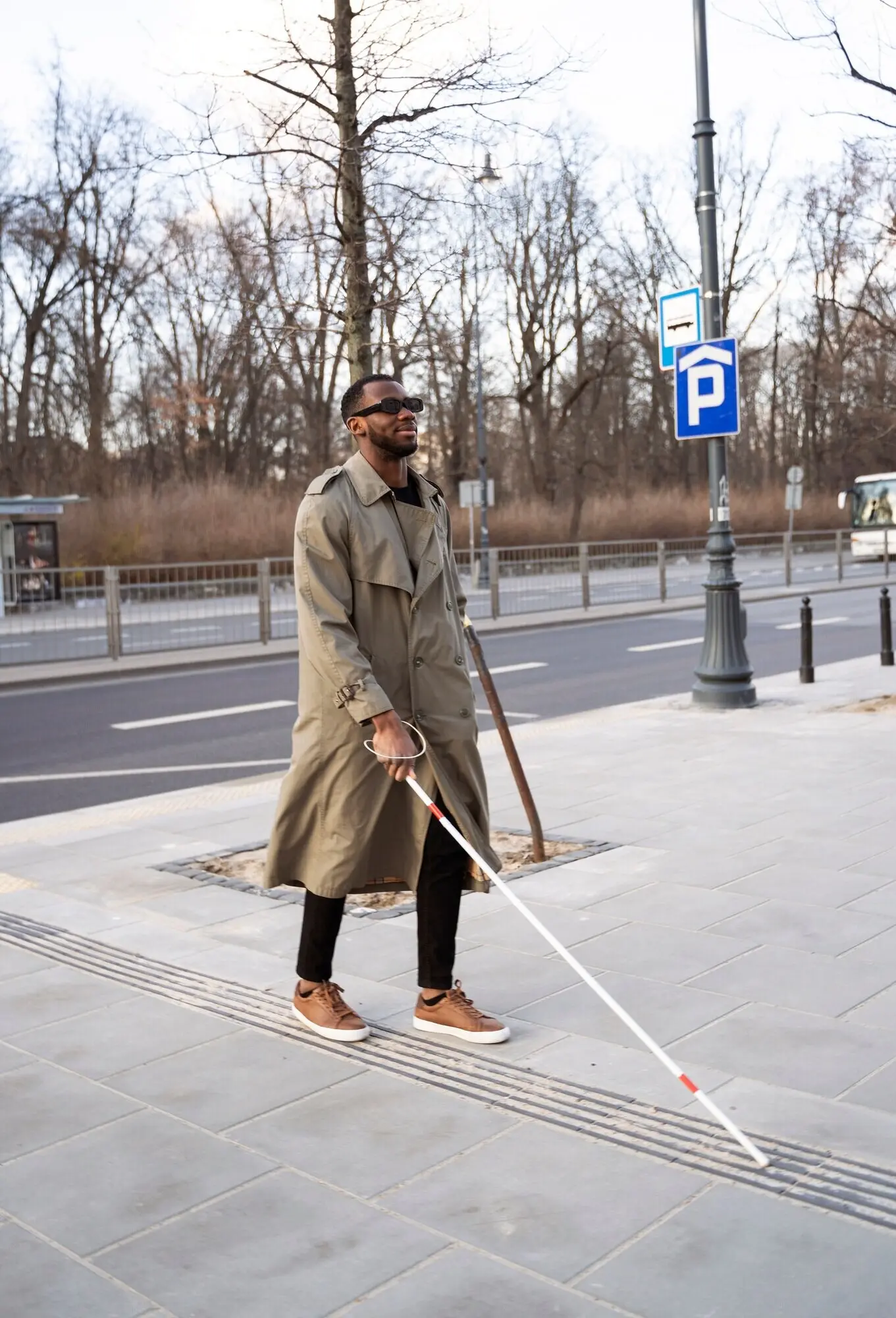
Curb Cuts and Truncated Domes

ADA-driven curb cuts and truncated dome tiles tell a legal and ethical journey toward inclusive mobility. Notice installation dates, tile materials, and alignment. Early retrofits differ from modern standards, creating a visual timeline of compliance, iteration, and maintenance priorities at the corner scale.

Repaving Cycles and Overlay Clues

When streets receive overlays, clues remain in manhole risers, curb reveal heights, and saw-cut seams. These discontinuities can date resurfacing campaigns, hint at budget cycles, and show where heavy vehicles or stormwater have stressed particular blocks, altering texture, drainage, and long-term repair strategies.

When History Gets Replaced

As segments are rebuilt, heritage inscriptions sometimes vanish. Document respectfully before construction, advocate for salvaging notable pieces, and ask cities to re-embed stones or stamp replacement pours. Thoughtful preservation can keep neighborhood identity tangible while still delivering safety upgrades and modern accessibility standards.

The Lost Trolley Track

One reader shared finding trolley-rail scars revealed during milling, then traced them to a 1947 abandonment notice in newspaper archives. That discovery reconnected a quiet street to a once-bustling transit line, reframing front steps as platforms and corner stores as informal stations.

Neighbors as Historians

A neighborhood group cataloged contractor stamps along a single avenue and noticed a gap after a major flood year. Their photos, paired with aid records, showed which blocks were rebuilt first, sparking conversations about equity, resilience, and why some repairs aged beautifully while others failed early.

A Stamp That Solved a Puzzle

While documenting dates, someone spotted a paw print beside a crisp 1931 stamp. An elderly neighbor remembered the mason’s dog and the celebratory lemonade stand kids ran that afternoon. Small details humanize infrastructure, transforming cement lines into remembered afternoons, friendships, and ordinary, cherished triumphs.

Get Involved: Share, Subscribe, and Explore Together

Curiosity thrives in community. Share discoveries, ask questions, and help neighbors read their streets more attentively. By pooling photos, notes, and local knowledge, we can build an open, respectful resource that honors maintenance crews, safeguards utilities, and celebrates the everyday artifacts beneath our feet.

How to Contribute Sightings

Submit sightings with clear photos, cross streets, and approximate installation dates if known. Note accessibility details and any visible hazards so agencies and residents can respond constructively. Thoughtful contributions improve data quality, inspire fresh expeditions, and earn credit in periodic neighborhood highlight roundups we publish.

Connect with Local Agencies

Introduce yourself to public works staff at community meetings or open houses. Ask about markings you have documented, and request guidance for safe observation. Respect work zones and privacy; a friendly approach turns curiosity into rapport, unlocking context you cannot glean from inscriptions alone.

Subscribe for Ongoing Discoveries

Subscribe to our updates for deep dives into local infrastructure, field guides, and printable checklists. We highlight reader submissions, share workshop dates, and announce collaborative mapping drives, turning occasional strolls into purposeful adventures that sharpen observation skills and strengthen neighborhood bonds week after week.
Vazekipalefanuvi
Privacy Overview

This website uses cookies so that we can provide you with the best user experience possible. Cookie information is stored in your browser and performs functions such as recognising you when you return to our website and helping our team to understand which sections of the website you find most interesting and useful.